Pair lost trail, then split up to find it
|
August 19, 1978 |
 |
By Jim Fairchild
The Whitewater Drainage originates from the very top of Mt. San Gorgonio, 11,501' el., Southern California's highest mountain. Four major forks descend easterly and southeasterly, joining to make one broad wash at about 4500' el. The Pacific Crest Trail, the 2600 mile route from Mexico to Canada, enters Whitewater Canyon where Interstate 10 crosses. The trail proceeds northward past the Whitewater Fish Hatchery and two miles farther north into a side canyon and over ridges into the Mission Creek Drainage.
Kent and Richard missed the PCT where it leaves Whitewater Drainage. They split up to try and find it. They stayed split. Richard realized the problem as he hiked up the wash. He spent a day and a half crossing and searching the area many times. Then he hiked out and finally alerted the Sheriff at the Banning Station.
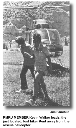
RMRU arrived at the hatchery and set up base. Sgt. Weakley procured the San Bernardino Sheriff's Hughes 500C helicopter just after the initial party of Dew and Chambers left the hatchery to cover the first part of the canyon. Kevin Walker and I were dispatched into the field along with Richard, the informant, to check the area of "splitting" and try to establish a direction for the lost Kent. Jim Garvey went with three men in a 4WD machine from Hemet to check the road that penetrates Whitewater from Mission Creek, ending at Wathier Landing at about 4000' el.
Kevin and I searched the area, finding where Richard had built a signal fire the first night they split. Dew and Chambers joined us. Garvey reported the subject's tracks in the wash near Wathier Landing. We asked that Dew and Chambers be lifted up there - they were. Kevin and I awaited our turn; we wanted to check the Middle Fork to see if Kent could have in some miraculous way managed to get into the North Fork, or go over the headwall of the Middle Fork. Both routes were tricky, the headwall quite treacherous. We finally, through Roland, the Operations Leader, got a hold of the helicopter, but when it flew over we heard the dismaying command, "Continue hiking up the canyon." We asked to be lifted into the Middle Fork two more times, but got the same command each time. Suffice it to say, we were miffed. Radio silence prevailed until about 5 pm, when the machine arrived and we were told the Sgt. had found tracks up the Middle Fork. Dew, Chambers, Walker and myself were soon up there following tracks up the ever steepening canyon. The walls closed in, enormous jumbles of boulders and recently fractured bluffs rose close by. As the angle increased, we encountered Class 4 scrambling up active waterfalls. Dew stayed behind as relay. We still had Kent's tracks, but lost them about 400' below the top of the headwall. Long, steep, constantly moving slides of sand and gravel made it impossible to tell whether Kent took a side chute to escape the direct route. We were now on the tracks of a small black bear and a deer. Kevin was above us, almost to the top, 8000', Don Landells arrived in his powerful bird and plucked us off that loose mess - just stuck one skid into the matrix and held the machine as we clambered aboard. Flying out we searched the Middle Fork's upper reaches and were even further impressed by its ruggedness.
Back at Base we heard that a party from the 303rd ParaRescue unit had found a single track west of the headwall. Our hunch was right on.
 The next morning, due to a mix-up,
we got airborne at 0900, instead of 0630. We flew
close search up the South Fork, then into the
East Fork. Kent later said we flew over him. His
clothes matched the canyon walls perfectly, and
we were going higher and faster at that point.
Kevin and I got out on a small peak south of the
Middle Fork headwall. We had just arrived where
the single track was marked when word came of
Kent's being spotted from Landells bird. We
hustled toward the area - about a half mile north
of where the East and South Forks join. A 303rd
party was hiking downstream on Kent's tracks and
was ten minutes away when he was spotted. The
difficult terrain caused quite a long delay in
getting him out.
The next morning, due to a mix-up,
we got airborne at 0900, instead of 0630. We flew
close search up the South Fork, then into the
East Fork. Kent later said we flew over him. His
clothes matched the canyon walls perfectly, and
we were going higher and faster at that point.
Kevin and I got out on a small peak south of the
Middle Fork headwall. We had just arrived where
the single track was marked when word came of
Kent's being spotted from Landells bird. We
hustled toward the area - about a half mile north
of where the East and South Forks join. A 303rd
party was hiking downstream on Kent's tracks and
was ten minutes away when he was spotted. The
difficult terrain caused quite a long delay in
getting him out.
Later, Hal Fulkman and I were flown in by Don to retrieve Kent's pack - he had tied it to a small tree thirty feet below the headwall about three hundred feet up from the pass itself. Of course, he had absolutely nothing with him his last night and day in the wilderness. But, being along water, he survived.
The above is a short summary of the story. I could write a book on the mission to make it complete. But that's as usual. Maybe someday well do just that on a particularly long and difficult operation.